Evan’s Notch – Route 113 – A Maine Scenic Byway
Warning: Use of undefined constant gad_content_tag_filter_replace - assumed 'gad_content_tag_filter_replace' (this will throw an Error in a future version of PHP) in /home/dx87kwtjkt0i/public_html/wp-content/plugins/web-ninja-google-analytics/webninja_ga.php on line 1813
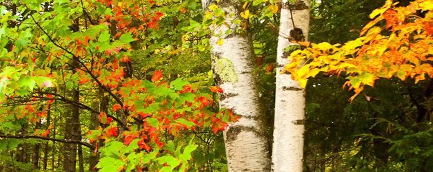
Currier and Ives ‘prints’ present themselves in the moment. The reds, oranges and yellows of Fall, the pungent smell of wood smoke from wood stoves taking the chill off the day, or the advancing hues of green with the coming of Spring are all evident in the seasons that book-end the route through the Notch. Find your way to Evan’s Notch via Route 113 N; serpentining along the Maine – New Hampshire border!
Be prepared to take your time, to stop and read, to look and listen; get out of your car, get off your bike. Travel through history; colonial era cemeteries, churches and established family names, original town buildings and farmsteads; that, and the roadside geology, all the while escaping the crowds and traffic. No matter the season, the day traveler will celebrate a visual feast: the stark yet beautiful backwoods New England of old, a marvelous mix of derelict-to-prosperous farms and homesteads with a forested, hill-and-dale drive giving way to wide open vistas of unexpectedly rich farmland, and the time and weather-worn rugged Appalachian Mountains as one’s ultimate destination.
Once experienced, Evan’s Notch via Route 113 becomes the visual yardstick, defining the vision of, rural northern New England.
Route 113, claimed by the State of Maine as a Scenic Byway, leaves the town of Fryeburg as River Street at the corner of Main and River Street (Mile 00.0). The traveler will find no strip-mall development, a la North Conway, for the town of Fryeburg. Grand old New England homes front Main Street with property running ‘forever’ back to the river. The only real excesses the town of Fryeburg seems to allow itself are the Oxford County Fair, better known as the Fryeburg Fair, taking overt in early October and the legions of recreational canoeists that float (party) down the Saco River during the brief New England summer. The traveler leaves town quickly on River Street, over a wooded knoll past the Weston’s well-kept and prosperous brown and tan Rivercroft Farm, crossing the wide sluggish Saco River. The intervale stretches out to the north and the mountains containing our destination form in the distance.
* * *
Let us dispense with some colloquial terminology so the traveler can feel like a New Englander at least, if not yet like a local. A distinctly New England term for a rich flood plain, river bottomland is intervale. In this case, the intervale is that of the Saco River. The Saco River has a couple of courses to run, the ‘old course Saco‘ and the ‘canal river’; more later in our journey. An oxbow lake is usually a crescent-shaped body of standing water formed from a single loop cut off from a meandering river or stream, typically by a flood that allowed the stream to flow through its floodplain (intervale) and bypass the loop. Oxbow can also mean a U-shaped bend in a river or stream, whether or not it is cut off from the main stream. Mountain passes formed by river erosion are ‘V’ shaped and are referred to as just that, a pass. In New England the glaciers’ rivers of ice scraped and shaped both the bottom and sides of existing mountain passes transforming them into ‘U’ shaped notches. Northern New England‘s mountain notches are visually distinctive on its horizon.
* * *
Crossing the Saco and the intervale at Weston’s Bridge brings the traveler into the great state of New Hampshire and past the white and green-roofed Sherman Farm. The traveler following Route 113 N into New Hampshire (Mile 01.2) will turn right at the ‘T’ onto the East Conway Road. Across the intervale, up against the forested mountains the traveler passes many wood framed clapboarded farmstead homes and barns. The strength and length of the winter months prompted northern New England farmers of old to attach their homes to their out buildings and barns such that they would not have to venture out of doors to see to the daily chores. Hence, the rambling farm houses with multiple ells that arrive at the connected barns. Crossing back into Maine, (Mile 02.3) the East Conway Road transforms itself via signpost and a change in state line into the West Fryeburg Road and Route 113 N continues towards Evan’s Notch.

The road floats back and forth between open farmland and wooded hill and dale. The West Fryeburg Cemetery (signed circa 1795) (mile 03.9) contains fenced manicured family plots: Haley, Hutchins, Andrews, Walker, Hardy, Stevens … fences of silver painted iron piping, some of quarried granite; a tidy place, mown and free of past-their- prime flower arrangements. Someone honors this resting place with their time and attention.
The harvest-time traveler passes a farm truck hauling a load of what appear at first glance to be dirt clods, as it disappears in the rear view mirror south, the traveler has to chuckle recognizing the load as harvested potatoes. The forested hill and dale drive gives way to a long 180-degree view of open farmland backed by the mountains. The road runs into the trees up close along sluggish river oxbows. The river appears to have very little or no current.
* * *
The Saco River used to define and own this land and the intervale. The river would flood yearly and enrich the soil but also leave the ground so wet that it could not be farmed early enough given the short northern New England growing season. Different stories abound but one of the more colorful has a group of 1800 era farmers banding together, under the cover of darkness, with multiple oxen teams to plow furrows connecting oxbows in the ‘old course Saco River’ such that a ‘river canal’ was formed. Lo and behold, given the passage of time and more to the point the passage of water, this six mile long ‘river canal’ is now the acknowledged course of the Saco River. The Saco River is 15 miles shorter than its ‘old course’. This allows for successful cultivation of prime intervale land.
* * *

In the midst of the intervale farms of North Fryeburg is the shaded Charles Cemetery (signed circa 1838) (Mile 08.2). Hardwoods stand sentinel over lichen-covered slate and granite head stones from the past in the midst of thriving cornfields. Touching the slate stones, following weather worn groves still makes it difficult to decipher names and dates. Cemeteries always have a palpable presence and this one does not disappoint. The West Fryeburg Road (Route 113 N) meets Fish Street in the small almost-becoming-a-memory village of North Fryeburg. The dark green and white Universalist Chapel (Mile 08.2), as its name implies, still provides spiritual comfort and guidance to and for all. The steepled chapel is distinctive in its monochrome plainness among the guardian hard wood trees and the whispering cornfields. Further on the North Fryeburg Cemetery, (signed circa 1819), holds stone silent testimony to McKeens, Walkers, and Smiths; Wileys, Bachelders and Tibbetts. Pete’s Garage, no neon-lit-signage here, offers service and used cars; but seems to be biding its time until the winter snows come and it becomes a mecca for snowmobile enthusiasts
Continuing on Route 113 N the traveler leaves the village of North Fryeburg, Maine crisscrossing back into New Hampshire and the town of Stow (1833) (town line at Mile 09.9). Watch for the hand lettered all askew wooden ‘Fudge for Sale’ sign. Check it out. The road surface continues its smooth effortless meanderings bringing miles of smiles to cyclists of all persuasions. Route 113, in both Maine and New Hampshire, is a well-maintained state road that will bring a smile of approval to any cyclist’s face. The Stow Corner Store (Mile 11.8) deserves a stop, especially if one is in need of an ice cream fix. The ice cream portions offered up bear no relation to reality or to the cones, they stand atop. Bearing right on Route 113 N, the road climbs up on to a forested ridge and proceeds out of the tiny crossroads village. This far out, properties are either over-grown snow-toppled derelicts or a mix of well-kept, well-appointed old and new homes and properties. The older homes and farmsteads demand and get someone’s time, attention and resources in order to remain in such a functional yet truly back-in-the-day state. This is wonderful – a source of regional pride: Northern New England and New Englanders at their best!

Further, on Route 113 N, open farmland gives way to the mountains, no longer in the background. What was once a distant view is now a 270 degree in-your-face presence. Crossing into the town of Chatham (correctly and pointedly pronounced: Chat-Ham) (Town and State Line, Mile 14.9) and back into New Hampshire the mountains and upcoming Notch become the traveler’s focus. The mountains overhwelm. Out of nowhere, brick farmhouses present themselves and the ‘Eastman’ name predominates; chiseled in the cemeteries, painted on the mailboxes and proclaimed on the farmsteads. One, Robert K. Eastman, received a revolutionary war era grant of land on or about 1796. Robert Eastman Sr. proved up that land, sired four sons and four daughters and built a four-chimney brick colonial farmstead. Upon Robert Senior’s death, (or maybe before), the Eastman land grant was divided up among his son’s and daughter’s farming families. The Eastman family name and the brick family farmsteads accompany the traveler up Route 113 N through Chatham. The Chester Eastman Homestead land (Mile 15.7) contained the clay deposit and the kiln, back-in-the-day, to supply the brick for the half dozen or more brick homes in the immediate area. The ‘blue’ clay would have been dug and worked during the summer months, the bricks kilned and ‘burnt’ during the fall, then transported via sled and oxen team when snow was on the ground, and construction would finally begin with the coming of Spring.
Cemeteries abound along Route 113 N through Chatham. A second Charles Cemetery (signed circa 1817) (Mile 17.3) populated by the Eastman surname and seemingly containing the Eastman family patriarch’s grave. Further on the Chandler Cemetery (signed circa 1790) and a stop-and-get-the-camera-out view beckons: a northern New England farmstead, with the locally iconic Baldfaces rising immediately beyond, to the west. Tree line in the White Mountains of New England is roughly 4500 feet above sea level; the Baldface summits are at roughly 3600 feet with treeless open ledgy summits. At the turn of the century, a fire burnt over the Baldfaces and they have remained open and treeless ever since. The loop trail over the treeless summits of the Baldfaces, while spectacular and worthy of the effort, will consume the well-prepared traveler’s entire day.
* * *
If intending to hike in the Whites Buy an AMC White Mountain Guide, treat it like the outdoor bible it is. Follow its advice and directives religiously. The Baldface Circle trailhead (Mile 17.5) offers parking and toilets to the traveler/hiker. About a mile in on the flats of the loop trail up to the summits of the Baldfaces is a side trail to Emerald Pool. Great spot! A hot summer day makes this is a worthy walk with a mountain-stream-water-fall-fed brisk dip at the end.
* * *
Evan’s Notch still beckons and the day traveler, continuing on Route 113 N, leaves the woods and once again confronts the White Mountains and Evan’s Notch, enveloping and defining the scenery ahead. Darkening clouds obscure some of the summits, the surrounding low country still sunny and clear. The Notch and mountains seemingly generate their own weather patterns. Basin Camp (Mile 19.7) provides toilet facilities, seasonal camping, and trailheads to access the mountains.
If one has the option and you have not yet put the top down; do so now. Past the seasonal gate and back into the state of Maine, the road tightens down to two lanes, sans the luxury and safety of shoulders. The last brick homestead, the last homestead period, going into the Notch, is the Brickett Place (Mile 20.0). White Mountain National Forest (WMNF) crews are painstakingly restoring the historical structure. Stop for a quick look. A hardwood and pine mix canopies the road up into the Notch. Openings in the canopy of leaves and branches reveal blue sky and the granite rock walls of the Notch. Depending on the season of the year, the light filtering through the canopy is a haze of many hued greens or reds, golds, greens and yellows. A consistent steady ear-popping climb will have the traveler powering down if on a motorcycle or running back and forth through the gearbox if in a roadster. While there is the temptation not to, pay close attention to the roadway. The twisting and turning, the bouncing with the frost heaves lasting well into the driving season, and the tightness of the roadway all conspire to make the driving a challenging pleasure for the traveler. The views alternate between the near and far; making for a constant mixing of visual input, like the flickering of an old movie. The birch and beech trunks become exclamation points amongst the seasonal color.

Nearing the height of land the canopy of leaves and branches thins out some giving way to the much-anticipated long views. Turnouts on both sides of the road are available just below the height of land (Mile 21.9). Check out the long sought panoramic view back through the New Hampshire-Maine countryside just traversed, intervale, mountains and notch. Just a touch further into the Notch (Mile 22.3) is a tighter back-from-whence-the-traveler-has-come view as well as a view up and into the Notch, catching the precipitous granite ledges, the head craning heights, the nesting falcon, the tightness of the Notch walls, the colors in Fall, the roaring of spring freshets, the wildness that is Evan’s Notch. At this point, the traveler is near a watershed point: waters will either travel north to the Androscoggin River and the Atlantic Ocean at Merrymeeting Bay, Brunswick, Maine or south to the Saco River, its intervale and the Atlantic Ocean at Saco, Maine.
From this point on, Route 113 N, feels like Evan’s Notch, the ‘other side’. There is a marked and palpable change in the surroundings: maybe it’s shadow, maybe it’s the quality of the light, maybe the canopy has changed, maybe it is the Notch making it’s own weather, … or it is wilderness.

A high country bog (Mile 23.2) deserves a pause. A small turn out is on the left as the grassy wetland first presents itself; be on the lookout here (Mile 23.2) or you may miss a true opportunity. Stop, scramble down the small embankment. Look and listen; observe near and far. Pick your way through the tall grasses, choosing a dry path. At this point, running waters proclaim themselves, heard but not seen. The water runs well underfoot, the vegetation an anchored floating mat. Venture further; dark pools will present themselves. Lone pines, some alive and some dead, join the long stemmed grasses among the beaver backed pools of water. On the outskirts of this grassy wet land, are the mixed hardwoods rising on the dry land slope. Further in a beaver lodge rises above the grasses. At this point, it is becoming noticeably wet under foot. Feet are being suctioned, momentarily held. The water gurgles up around both feet. Go much further and water will breach one’s shoe tops. The traveler returns up the embankment to the roadway. Being out and immersed in the Notch’s surroundings, rooted in the Notch itself, is good, even if only briefly.

Passing another seasonal gate, the roadway roughens up and begins its descent. The mixed pine hardwood surroundings are darker, with the canopy covering the road once again. Dark shadows flicker, the light now from behind. The roadway winds down quickly, not losing as much elevation as it gained coming up. The traveler pass Hastings Camp (Mile 27.2) The Fire Road (FR) to Wild River presents itself (Mile 27.5). The Wild River area is now a Federally designated Wilderness Area. This is affecting its use and access, a mixed blessing.
Route 113 N levels off beyond the Wild River FR leaving the WMNF behind. Wilderness views back up and down the Wild River valley abound. Route 113 N is now a smooth well kept recently paved surface; no longer a seasonal national forest road. Route 2 running East and West confronts the traveler with choices: Go east to the town of Bethel, Maine, and find food and drink. Go west to Gorham, New Hampshire then heading back south to the crowds of the Conways (more food and drink) via Route 16 and Crawford’s Notch.
This traveler will choose to return via Evan’s Notch, if only to see how the change in direction and time of day reorients the entire experience.


Thanks for an idea, you sparked at thought from a angle I hadn’t given thoguht to yet. Now lets see if I can do something with it.
this post is very usefull thx!
Beneficial info and excellent design you got here! I want to thank you for sharing your ideas and putting the time into the stuff you publish! Great work!
Great work keep it coming
Thanks for the post
I just added your blog site to my blogroll, I pray you would give some thought to doing the same.
terrible register you’ve carry
tell me more?
nice post. thanks.
fat chart you procure
Wonderful post. I learn something new on different blogs everyday. The first couple stimulating to enjoy a book content from other writers and study a little something their particular. I want to use some of your content on my blog if you can not mind. Natually I’ll offer a link back to your websites. Appreciate your sharing sharing.
Resources just like the one you talked about right here will likely be very helpful to me! I will post a link to this page on my blog. I am sure my visitors will find that very useful.
I am very interested in others ideas about this, even if I don’t always feel the same!
This is really a extremely beneficial read for me, Have to admit you might be 1 in the most effective bloggers I ever saw.Thanks for posting this informative article.
I have been reading out many of your posts and i must say nice stuff. I will surely bookmark your website.
I have read few of the articles on your site since yesterday, and I really like your style of blogging. I added it to my favorites blog list and will be checking back soon. Pls visit my web site as well and let me know your opinion.
I found your entry interesting do I’ve added a Trackback to it on my weblog :)……
Your place is valueble for me. Thanks!…
I want to thnx for the time you have put in writing this blog post. I am hoping the same high-grade work from you in the future as well. In fact your creative writing abilities has inspired me to get my own blog now. Truly the blogging is spreading its wings quickly. Your write up is a fine example of it.
Emjoyed reading this blog, just wanted to say thank you
This really answered my problem, thank you!
Fantastic article! I’ll subscribe correct now wth my feedreader software package!…
You are not the common blog writer, man. You definitely have something important to add to the World Wide Web. Such a outstanding blog. I will be back for more.
Fantastic article! I’ll subscribe correct now wth my feedreader software package!…
A well written article, I just passed this onto a university student who was doing a little analysis on this. And he in fact purchased me breakfast because I discovered it for him. :).. So let me rephrase that: Thank you for the treat! But yeah Thnkx for taking the time to discuss this, I feel strongly about it and love learning more on this topic. If possible, as you gain expertise, would you mind updating your blog with more info? It is extremely helpful for me. Big thumb up for this blogpost!
Cool!!! Good point of view, loved it. Great site, congratulations.
Valuable info. Lucky me I found your site by accident, I bookmarked it.
Great information and the picture of the farm at the top is beautiful. My maiden name was Eastman. My family use to go to that farm (my grandparents farm) every year for Thanksgiving. I was looking for pictures of the farm on google. Thank you for sharing all of your images and knowledge. I miss going there to hike and play.
Veery good information. Luccky me I discovered your blog by chanhce (stumbleupon).
I’ve savd as a favorite for later!
Howdy veгy nice site!! Guy .. Beautiful .. Superb ..
Ι’ll bookmark yоur webb site аnd take tҺe feeds also?
I’m satisfied tо seek out a lot оf helpful iոformation Һere in the submit,
we need wotk оut more strategies оn this regard,thankѕ fоr sharing.
. . . . .
This site truly has all the information I wanted concerning this subject and
didn’t know who to ask.
wholesale nfl jerseys
Excellent blog right here! Also your website a
lot up very fast! What web host are you the use of?
Can I am getting your affiliate link on your host? I want
my website loaded up as fast as yours lol
allposts